On World Water Day 2021, which is held every year on 22nd March, the Brenner Base Tunnel Society (BBT SE) is drawing attention to a positive effect of the construction works. The insights collected throughout the years by BBT SE experts can now be applied in the Sill and Inn river areas in Tyrol to help establishing better flooding forecast. Interdisciplinary pilot projects merged with the skills of experts to protect our communities from floods.
The improvements to the flooding forecast models are based on comprehensive cooperation across sectors as well as a combination of technical knowledge within the hydrogeological sector. The data on water balance necessary for this objective can be found in analyses carried out in the past decades for the Brenner Base Tunnel. The main focus lies in quantifying underground outflows. It also allows to quantify the groundwater and mountain water running below the surface during heavy precipitation as well as in the watercourses above the ground, which are more linked to flooding.
"We have access to detailed knowledge which is only available thanks to the Brenner Base Tunnel project and which ultimately increases the protection of the population against flooding" explains the Head of Geology and Hydrogeology at the Brenner Base Tunnel, Ulrich Burger. "Our pilot project 'Water Balance Models of Alpine Catchment Areas' not only provides findings about our essential underground water resources, but it also offers the chance to improve the flooding forecast models for rivers and brooks".
On the one hand, this information is necessary for the tunnel construction works to predict water inflows in the tunnel. On the other hand, it was used for hydrogeological risk analyses for water resources. As a matter of fact, water balance models clarify how much water runs above the ground and how much runs underground. For the construction works of the Brenner Base Tunnel, the relevant sections of the Sill catchment area have been considered.
Main construction phase of the project to begin in autumn 2021
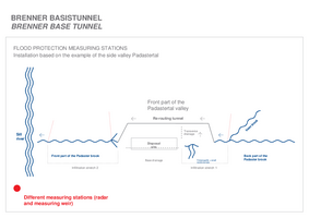
Eight geologists and hydrologists are currently working on this pilot project, together with several people responsible for measurements on site. In the pilot phase, necessary data for the research is collected from approx. 35 representative selected measuring stations (measurements on precipitation, groundwater, channels and springs).
Values on water have been recorded by the Brenner Base Tunnel project since 2001 and the data in the studies for the project mostly refer to the past 10 years. The study for the pilot project should be completed by June 2021. The main phase of the project should then start in autumn 2021 and last 2 years.
Cooperation towards sustainable protection for the environment and against flooding
The pilot project is the result of cooperation between the Austrian Research Centre for Forests (BFW) and BBT SE. "The outflow processes of the alpine catchment areas are complex. For this reason, interdisciplinary cooperation across different sectors is necessary to develop an understanding of water balance, as well as possible modelling approaches" says hydrologist Klaus Klebinder from BFW, describing the advantages.
The rich data pool of the Tyrol Hydrography and Hydrology Department and the Central Institute for Meteorology and Geodynamics (ZAMG) is also being used. The objective for the next phases of the project is to expand the group. Extensive discussions are already underway with a large number of Universities working with a focus on hydrography, hydrogeology, water management and flood forecasting.


